We mapped a lost branch of the Nile River – which may be the key to a longstanding mystery of the pyramids
- Written by Timothy J. Ralph, Associate Professor, Macquarie University
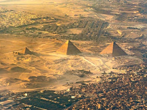
The largest field of pyramids in Egypt – consisting of 31 pyramids built over a millennium, including the famous Great Pyramid at Giza – lies along a narrow strip of land in the desert several kilometres west of the Nile River.
The Nile was at the heart of ancient Egyptian civilisation, and the location of so many pyramids some distance away from the river has until now not been fully explained.
In a new study published in Communications Earth & Environment, we addressed this puzzle. When the pyramids were built they sat next to a now-vanished branch of the Nile, which likely provided transport for workers and their materials.
A changing river
Like other rivers, the Nile adjusts and changes over time in response to climate change, floods and droughts. People and places also move with the river. In the past, civilisations fell and rose on its ebb and flow.
The Nile has not always looked or functioned the way it does now. By reading the landscape in Egypt, traces of the former river and its branches can be found hidden just beneath the land surface.
Now obscured by areas of cultivation and urban settlements, buried by centuries of mud from the modern river, the old channels and their stories have largely been lost to time. Once a mosaic of waterways and wetlands, the Nile is ready to share its secrets again.
Many scholars have discussed and sought answers to the mysteries of the Nile. Previous research has documented evidence for the existence of parts of ancient waterways or wetlands, particularly near the Giza pyramids.
Upstream near Luxor, Nile migration patterns have been investigated, and downstream abandoned channels have been discovered in the Nile Delta. Yet until now we did not have a comprehensive map and understanding of the waterways that fed the extensive pyramid chain from Lisht to Giza in the past.
The Ahramat Branch

Using satellite imagery, high-resolution digital elevation data and historical maps, we identified and traced the long path of a previously unknown channel of the Nile. What we have called the Ahramat Branch once flowed along the Western Desert margin of the Nile floodplain, close to the ancient pyramids.
Many of the pyramids, built during the Old Kingdom (roughly 2700–2200 BCE) and the Middle Kingdom (2050–1650 BCE), have causeways that lead to the branch. Many of these paths terminate in temples that may have acted as river docks in the past.
This suggests the Ahramat Branch was active during multiple phases of pyramid construction and was probably used as a transportation waterway for workmen and building materials to the sites.
Some pyramids have longer or differently angled causeways than others, indicating the builders adapted their construction approaches to the changing riverscape and local conditions at the desert margin.
 Members of the research team stand in front of the pyramid of Unas’s Valley Temple, which acted as a river harbour in antiquity.
Eman Ghoneim
Members of the research team stand in front of the pyramid of Unas’s Valley Temple, which acted as a river harbour in antiquity.
Eman Ghoneim
Other pyramids were connected to inlets associated with tributaries of the Ahramat Branch on the edge of the Western Desert. In all, analysis of the ground elevation of 31 pyramids and their proximity to the floodplain helped explain the position and relative water level of the Ahramat Branch during the time between the Old Kingdom and the Second Intermediate Period (roughly 2649–1540 BCE).
Digging deep
Once we had mapped the Ahramat Branch, we surveyed the landscape and its shape, and took deep core samples of soil and sediment to study the structure and sedimentology of the former river. We also worked with archaeologists, scientists and members of local communities to gather more context for our work.
The path of the defunct waterway lies between 2.5 and 10.25 kilometres west of the modern Nile river.
Our research suggests the branch ran for about 64 kilometres, was between two and eight metres deep, and between 200 and 700 metres wide. This is similar to the width of the river today.
At one of the sites we examined, near the town of Jirzah, the Ahramat Branch has a symmetrical channel shape. It has also been filled in with muddy and sandy sediment different to other surrounding deposits and the underlying bedrock. This indicates that the old channel has been slowly buried by fine sediment deposited by floods, as the main flow diverted towards the path of the modern river.
What happened to the Ahramat Branch?
Over time, the Ahramat Branch moved eastward and eventually water stopped flowing along it. We don’t know exactly why. Perhaps the Ahramat Branch and its daughter, the modern river, were active together for a time.
The river may have gradually moved to the lower-lying floodplain, towards the current location of the Nile. It is also possible that tectonic activity tilted the whole floodplain to the northeast.
 Eman Ghoneim studies the surface topography of the section of the ancient Ahramat Branch located in front of the Pyramids of Giza and the Great Sphinx.
Eman Ghoneim
Eman Ghoneim studies the surface topography of the section of the ancient Ahramat Branch located in front of the Pyramids of Giza and the Great Sphinx.
Eman Ghoneim
A third possibility is that an increase in windblown sand may have filled up the river’s channel. Increases in sand deposition are most likely related to periods of desertification in the Sahara desert in North Africa.
The movement and diminishing of the Ahramat Branch might also be explained by an overall reduction in water flow due to reduced rainfall and greater aridity in the region, particularly during the end of the Old Kingdom.
This research shows that a multidisciplinary approach to river science is needed to gain a better understanding of dynamic river landscapes. If we want to understand and protect the rivers we have today – and the environmentally and culturally significant sites to which they are inextricably tied – we need a greater appreciation of the interconnected factors that affect rivers and how they can be managed.
Authors: Timothy J. Ralph, Associate Professor, Macquarie University